
Political Map
- Heathrow Airport in London is the busiest air port in the UK. In 2012 they had 70,037,417 passengers.
- London, Liverpool, Manchester, Birmingham, Bristol, and Leeds are the major cities in the UK.

Physical Map
- A major river is the Thames river.
- Another major body of water is the English Channel
- The North Sea is on the eastern side of the UK
- River Mersey in North West England
- Liverpool Bay in northeast Wales
- Queensways Tunnel is a tunnel under the Mersey River (northwest of England)

Climate Map
- In the UK, the change in the weather is very often.
- In the summer the average temperature is 60 degrees.
- In the winter the average temperature is 0-40 degrees
- It rains often
- The UK is mostly marine west coast

Population Map
- Population: 64,097,085
- Most people live by the Thames river
- Also in London or big cities
- The least populated place is near Sweeden and up North
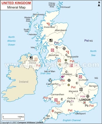
Resource Map
- Coal-North and South Wales
- Petroleum-South East England
- Slate-Wales
- Natural gas- on the coast
- Iron ore (barely)- Wales
- Mostly agriculture

Rainfall Map:
- North West England
- South West England
- Central Wales
